
Julia Ausloos-Bedinger
AIA, Associate
Due to the COVID-19 pandemic, it can be challenging—or even unsafe—for architects to visit a project site for prolonged periods of time, especially with multiple team members, to collect the information we need to successfully start and continue work on a historic preservation project.
For nearly a decade, Architectural Resources Group has been using digital documentation on many of our projects to increase efficiencies and provide better deliverables for our clients. As we adjust to a new remote work environment due to mandated “safer at home” orders, we’re relying on our digital documentation toolbox more than ever. Here are three of our primary tools.
360-Degree Photography
One of the simplest yet most effective digital documentation tools we utilize, 360-degree panoramic photography, lets us create Virtual Site Tours of our project sites. It’s essentially a custom version of Google’s Street View tool. We use a special camera that takes a 360-degree panoramic photo in about five seconds. We document every portion of the site and/or building that will be valuable to reference and look at later. Only one person is needed to perform the task, so we can follow social distancing guidelines.
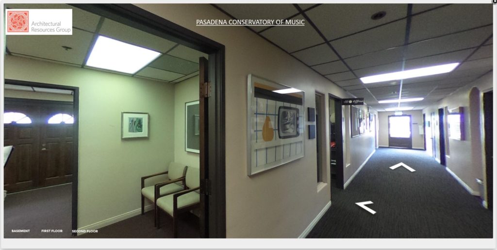
View within a Virtual Site Tour from a 360 degree panoramic image location. The white arrows on the floor indicate other panoramic image locations that can be viewed next.
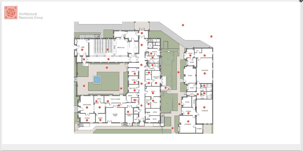
Example of a navigation floor plan within a Virtual Site Tour. Each red dot indicates a 360 degree panoramic image location.
Back at the home office, we use a specific software to create a virtual site tour, placing all the 360-degree photos onto a navigable site or floor plan for easy viewing. The software also takes the distorted view of the panoramic images and creates an orbital view, in which a viewer can easily pan and zoom around as if standing in the location the photos were taken. We upload the virtual tour to our website (with log-in credentials, of course!) and share it with the project team, including consultants and clients. This allows the entire project team to conduct a site visit from the comfort and safety of their homes, which is now essential during the days of COVID 19.
Photo Orthorectification
Another useful and low-cost digital documentation tool that allows us to document sites more quickly and with fewer people onsite is the orthorectification of digital photographs. We use this tool to measure a building relatively quickly so that we can create background drawings for an existing building. We simply capture photos of the building’s elevations, exterior and interior if required, as well as three simple measurements within the elevation: vertical, horizontal, and diagonal. We process the photos in the office, or at our home office, with a CAD-based software. The outcome is a scaled and orthorectified elevation image that we can easily trace in AutoCAD.
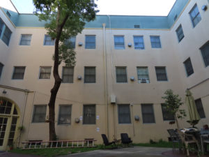
Exterior elevation view prior to being orthorectified.
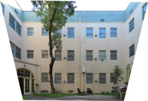
Orthorectified exterior elevation image. This image shows how the software distorts the original image in order to create an orthorectified and scaled image that can be traced in AutoCAD.
These scaled elevation images provide us with a lot of the information we need to complete background drawings, such as the length and height of walls, as well as door and window locations, which can then ultimately be translated into floor plan drawings. As with 360-degree photography, one person from the project team can collect all the images and measurements needed, in relatively quick time, to create a project’s background drawings. Therefore, this tool has become another way for our office to abide by the important COVID 19 guidelines, while also continuing work without interruption.
Laser Scanning
When a project can afford it and when the precision and accuracy of our background drawings is critical, we turn to laser scanning documentation. We work with qualified consultants to create an accurate 3D point cloud model of a project site. This produces much more accurate and complete data outcomes than orthorectified elevation images, but often also comes with a higher price tag. However, this documentation tool is invaluable for projects that consist of complex building types or sites, in which orthorectifying elevations would be much too difficult, or simply impossible.
One of the biggest benefits of laser scanning is the ability to virtually access a site, and its spatial data. With one or more laser scanners, one person can easily document an entire site in a relatively quick amount of time. The outcome delivered to ARG, is an accurate 3D point cloud containing the spatial data needed to build a Building Information Model (BIM). We often also utilize a tool called BIM 360, a cloud collaboration tool from Autodesk, that allows the whole project team to work in the same BIM at one time from geographically disparate locations. This allows the entire project team to work with the point cloud and see changes and updates to the BIM in nearly real time, ensuring that the project team is working with accurate and current information.
As the country battles COVID-19, and as we all begin to understand what our new working environment may look like, one thing we know will not change at ARG is our use of digital documentation tools that are making our lives easier and safer during these unprecedented times. Yes, these tools support a safer work environment during a pandemic, but they are also simply more efficient and accurate ways to work.
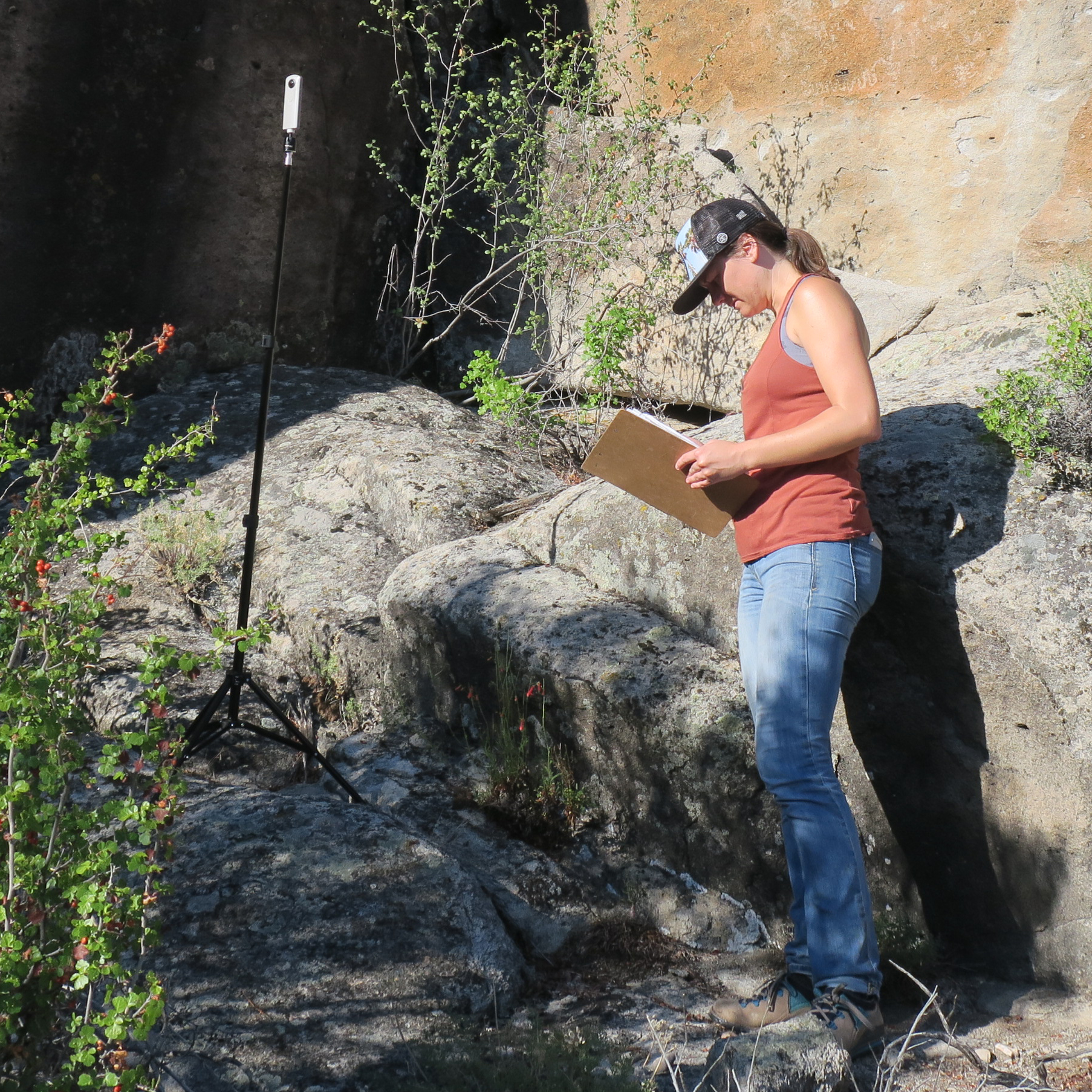
Capturing 360 degree panoramic photos at the project site for the Lincoln County Archaeological Initiative Pilot Study project.
Postscript:
ARG also utilizes these Digital Documentation methods to provide interpretive displays of historic sites for public benefit. Our most recent example of this was a pilot study we recently completed in collaboration with the Bureau of Land Management, Center of Preservation Research at University of Colorado Denver, G2 Archaeology, the Nevada Rock Art Foundation and LegionGIS.
For this pilot study, the project team digitally documented three archaeological sites in the Basin and Range National Monument in Lincoln County, Nevada. The digital documentation data was utilized to provide digital access to these very remote sites, while also providing a new form of interpretation for researchers and the general public.
To learn more about this project and experience the interpretive website developed by the project team, visit: http://lcai10.legiongis.com/